Pacasmayo Wind and Wave Forecasts

18 10 2011

I have been asked many questions about predicting the weather and swell by competitors attending the KSP wave kiting event here in Pacasmayo. The following is an attempt to answer those questions. The information and advice is based off realtime observations, watching the weather, talking to locals and reading forecasts over the last 2 months. If anyone can provide further insight into wind forecasting in Peru,  I am interested in hearing from you. Please leave a message in the comments section if you have something to say or if this post has helped you in some way.

One of the challenges about kitesurfing in a new place, is being able to read the weather like a local. I really try to understand how accurate weather forecasting is in a particular area. The long-term Peruvian wind forecasts are probably the worst I have encountered in the last 7 months of travelling to France, Sardinia, Brazil and Morocco. I almost didn’t come to Pacasmayo because of low wind forecasts , but have been pleasantly surprised that there is usually 12- 25 knots  if the sun is shining.

Because the waves in Peru often originate from such a long distance (15-20 sec period), wave forecasting is usually predictable a week out.  Locals I have talked to look more at the swell period (15 sec+) rather than height to predict when the good swell will arrive. Magic Seaweed or Windguru are both reliable sites for wave forecasting.

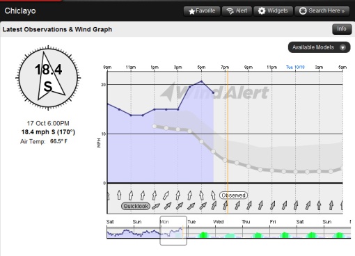
The most reliable real-time source of  wind information is the weather sensor in Chiclayo. This sensor provides a good indication of what is happening in Pacasmayo, despite being 50km away and inland. Wind Alert provides the easiest to understand wind stats and historical data from this sensor. If you want to see the raw data it can also be found on the NOAA website (select Peru and Chiclayo). Dewpoint and temperature are the most interesting as explained below.

Wind forecasting  in Peru is so erratic that I have given up trusting the long-range forecasts. Predictwind and Windguru are, however, your best sources of information and are usually more accurate on the day, providing the sun is shining. All the sites I have been following are particularly poor at predicting the cloud cover which might account for the erratic forecasts.

In Pacasmayo the wind blows more cross-shore in the morning and early afternoon swings to more cross off. The time at which the wind swings and peaks, can vary anywhere between 1-5pm. Often the best sessions are late afternoon after the wind has swung more cross off .

The following 5 sites are worth looking at;

Magicseaweed- http://magicseaweed.com/Pacasmayo-Surf-Report/3289/

Look for the high period days of 15 seconds or more.

Windalert- http://windalert.com/en-us/Search/SpotInfo.aspx?spotid=16193

Good for real-time and historical information, but don’t trust the forecasts. Look for the wind angle to be 180 or less and 20mph+ for a good session. Wind becomes more cross offshore and it’s easier to get upwind at angles of 180 or less.

Windguru- http://www.windguru.cz/int/index.php?sc=52627

Add roughly 30% or more onto figures that Windguru predicts. If the day is cloudy then the raw figures will be correct and it is time to go surfing instead of kiting. Any swell over 2-3 m with a 15+ second period will be the longest rides of your life!

NOAA- http://weather.noaa.gov/weather/current/SPHI.html

Good for real-time wind, temperature and dew point readings. For those that want to get more technical and detailed view of what is happening, this is your source. Dew point is critical when it comes to forecasting fog that is likely to kill the wind. Fog is likely when the surface air temperature and dew point temperature are the same. Dew point is however different from humidity as this article explains.

Predictwind- http://www.predictwind.com/

PredictWind is one of my favorite sites because it uses two independent weather models to predict the weather. Comparing the PredictWind forecasts (GFS or CMC) can give you confidence in the forecast. If CMC and GFS models are showing the same numbers then the forecast is more reliable.


NZ Summer Weather Outlook

17 12 2010

Wondering what the weather is going to do this Summer and want to optimise your kitesurfing/paddling holiday? Bob McDavitt the Metservice weather ambassador just emailed me some fantastic information in a way that makes sense for me. Hope this makes sense for you as well.  Thanks Bob!

This is a La Nina summer.  To understand the varying impact of La Nina on winds around New Zealand, let us first look at the three normal weather zones in our part of the world.  First, to the north we have the tropics with trade winds that mostly blow from the east. Second, to the south and in the “roaring 40s” we have a zone of disturbed westerly winds and the low-pressure systems of the Southern Ocean.  Third, in between, we have the latitude zone which we see cells of high-pressure take as they migrate from west to east across our weather map- let us call this the “sub tropical ridge”.

These weather zones tend to follow the sun.   The strong cool westerlies dominate our winter and spring when the sun is overhead in the northern hemisphere, and then recede to the south when the sun is seen to get higher in our sky during our summer.  Click on the animation above and watch how the orange belt, which marks the subtropical ridge, shifts from the Australian Bight / NZ latitude belt in summer, to the Australian Desert/north of NZ zone in winter.  This annual solar-driven cycle is so dependable we use it to name our seasons and we track time in years.
The second strongest weather cycle is called the El Nino-Southern Oscillation cycle (ENSO) At present it is in it’s La Nina phase and this occurs when the sea temperatures along the eastern equatorial Pacific Ocean go through an episode of being cooler than normal.  This can last for a year or so and the current event has already been going for six months and should last at least until autumn.

La Nina deflects the normal weather zones southwards around New Zealand.   The subtropical ridge shifted southwards across New Zealand during late spring, much earlier than normal this year, and that helps explains the dry period since Labour weekend and the late November “heat wave”.  This zone is likely to stay in the south until March so that the anticyclones may take a path along 45 South, as shown by the pink arrow in the weather map.  Individual highs may linger around southern New Zealand and the Chatham Islands, producing extended periods of dry sunny weather with light winds around the southwest of the South Island.

Watch the highs on the weather maps and  – when one of them peals off to east of Chathams Island, as shown above, note that northern New Zealand then becomes vulnerable to anything that more form in the tropics to the north.  If a low-pressure system forms north of New Zealand at this time then winds around it may combine with winds around the high like the wheels of an eggbeater, and focus their fury onto a localised area.  This weather map can produce a day or two of wind driven rain and heavy surf, and eastern places between Kerikeri and Gisborne are the most likely targets.

During the coming summer the windscape is, in general (but NOT all the time) likely to favor more than normal wind from between north and east- mainly affecting places northern and eastern parts of the North Island.  With the subtropical ridge lingering over the South Island that is the place where there may be extended periods of sunny dry weather with light winds.

The subtropical ridge should make its way north again around Easter.

Our seasonal weather outlook is also on our rural page ,
at http://www.metservice.com/rural/seasonal-forecast-north-island

Bob McDavitt
MetService Weather Ambassador
Meteorological Service of New Zealand Limited


Weather

21 07 2010

I am looking at the Predictwind ( http://forecast.predictwind.com/ ) forecast for Salvador and north. The map below map shows potentially what I am in for, lots of upwind!

The weather looks like SE 15-18 knots from the 21-24th July. Question is, can I trust this forecast? I would really like feedback from anyone living in the area from Salvador to Natal. Possible start date tomorrow or the following day if the wind forecast stacks up. Ideally I was hoping to start more on a southerly direction but at least there looks like wind.